India has issued a navigational warning regarding scheduled Global Navigation Satellite System (GNSS) jammer trials in parts of the Bay of Bengal.
According to alerts published on the National Hydrographic Office portal (hydrobharat.gov.in), the trials are scheduled from 9:00 AM on 11 April to 7:00 PM on 12 April (IST).
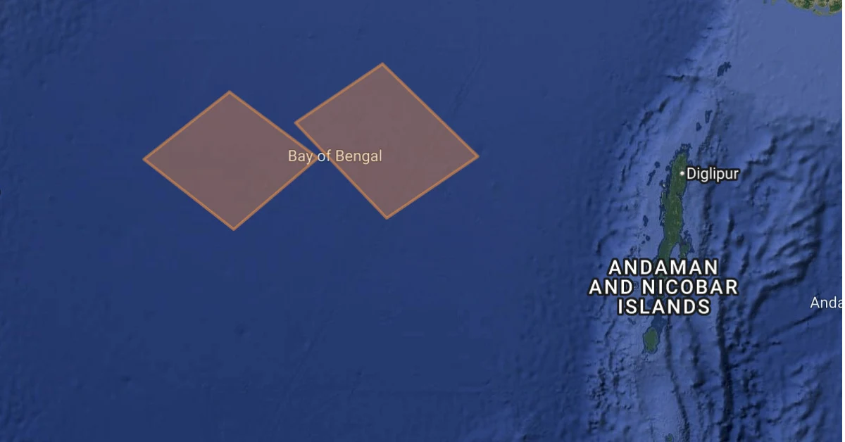
The trials will take place across two designated zones in the central Bay of Bengal, located off India’s eastern coastline.
While the official warning defines these areas using precise latitude and longitude coordinates, they broadly fall in offshore waters between the eastern coast of India and the Andaman Sea region.
The advisory will remain in force until 7:00 PM on 12 April 2026, after which it will stand cancelled.
Such NAVAREA warnings are issued to inform vessels about activities that may interfere with navigation systems.
GNSS jamming trials can disrupt satellite-based navigation signals, which may affect positioning accuracy for ships operating in or near the notified zones.
Mariners have been advised to exercise caution and avoid the affected areas during the specified period.
These warnings are issued under the NAVAREA VIII framework, through which India shares maritime safety information across the Indian Ocean region.
From a defence perspective, GNSS jammer trials are critical for testing electronic warfare capabilities in a controlled environment. Modern naval operations, precision weapons, drones, and surveillance systems rely heavily on satellite-based navigation, making them vulnerable to signal disruption.
These trials help assess how effectively Indian forces can operate in a denied or degraded navigation environment, where GPS or other GNSS signals are intentionally jammed during conflict scenarios.
They also allow defence agencies to validate countermeasures, strengthen resilience of military platforms, and ensure operational continuity of naval assets in high-threat environments, particularly in strategically sensitive regions like the Bay of Bengal and wider Indian Ocean.
In addition, such trials can be used to evaluate India’s ability to deny or degrade satellite navigation signals for adversary platforms. This includes testing how effectively hostile drones, ships, or precision-guided systems can be disrupted by controlled GNSS jamming in a conflict scenario.
Read also: IAF to get indigenous mountain radars as MoD signs ₹1,950 crore contract with defence PSU BEL